Mynd:OttomanEmpireIn1683.png

Stærð þessarar forskoðunar: 637 × 599 mynddílar Aðrar upplausnir: 255 × 240 mynddílar | 510 × 480 mynddílar | 816 × 768 mynddílar | 1.088 × 1.024 mynddílar | 1.966 × 1.850 mynddílar.
Upphafleg skrá (1.966 × 1.850 mynddílar, skráarstærð: 298 KB, MIME-gerð: image/png)

|
This historical map image could be re-created using vector graphics as an SVG file. This has several advantages; see Commons:Media for cleanup for more information. If an SVG form of this image is available, please upload it and afterwards replace this template with
{{vector version available|new image name}}.
It is recommended to name the SVG file “OttomanEmpireIn1683.svg”—then the template Vector version available (or Vva) does not need the new image name parameter. |
Lýsing
| Lýsing |
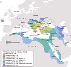
Deutsch: Karte des Osmanischen Reiches zum Zeitpunkt seiner größten Ausdehnung 1683.
Türkçe: Osmanlı İmparatorluğu en geniş sınırları (1683) |
| Dagsetning | |
| Uppruni | Self drawn, mainly based on Robert Mantran (ed.), Histoire de l'Empire Ottoman, Paris: Fayard (1989), also en:List of Ottoman Empire dominated territories, Image:Ottoman 1683.png, [1], and [2]. Background map modified from Image:A large blank world map with oceans marked in blue.svg. |
| Höfundarréttarhafi | Atilim Gunes Baydin |
| Aðrar útgáfur |
[]
|


Leyfisupplýsingar:
| I, the copyright holder of this work, release this work into the public domain. This applies worldwide. In some countries this may not be legally possible; if so: I grant anyone the right to use this work for any purpose, without any conditions, unless such conditions are required by law. |
Breytingaskrá skjals
Smelltu á dagsetningu eða tímasetningu til að sjá hvernig hún leit þá út.
| Dagsetning/Tími | Smámynd | Víddir | Notandi | Athugasemd | |
|---|---|---|---|---|---|
| núverandi | 17. september 2020 kl. 17:35 | 1.966 × 1.850 (298 KB) | Visnelma | Adjusted eastern and balkan borders, also vassals are added. | |
| 16. september 2020 kl. 22:36 | 1.966 × 1.850 (296 KB) | Visnelma | African coast of Red Sea was painted purple by mistake, I have corrected that. Also Georgia was an Ottoman vassal. I have added that. | ||
| 16. september 2020 kl. 21:42 | 1.966 × 1.850 (296 KB) | Visnelma | Athens and Morea was conquered during the reign of Mehmed II. Odessa and Moldova was conquered during the reign of Beyazid II. Hicaz and Yemen was conquered by Selim I. The region that connected Ottoman mainland and Crimea was conquered during the reign of Suleiman the Magnificent as well as Georgia. The territory on Persian gulf which is extension of Iraq was conquered during the reign of Suleiman, Ottomans never conquered Circassia. Furthermore Podolia was conquered during the 17th century,... | ||
| 31. maí 2014 kl. 17:49 | 1.966 × 1.850 (369 KB) | Spiridon Ion Cepleanu | New rectification since H.-E. Stier (dir.): « Westermann Grosser Atlas zur Weltgeschichte », 1985, ISBN 3-14-100919-8, pp. 96, 97, 103, 112 (because the accuracy is disputed) but with a better appearence I hope. | ||
| 6. mars 2013 kl. 17:58 | 1.966 × 1.850 (339 KB) | DragonTiger23 | Reverted to version as of 23:11, 10 December 2010 Returned the map to its original appearance. | ||
| 4. mars 2012 kl. 19:47 | 637 × 599 (172 KB) | Spiridon Ion Cepleanu | Little changes since Hans-Erich Stier (ed.), Grosser Atlas zur Weltgeschichte, Westermann 1895, ISBN 3-14-10 0919-8, pp. 103, 103 & 112. | ||
| 10. desember 2010 kl. 23:11 | 1.966 × 1.850 (339 KB) | Lambiam | Scale indicator more up to actual scale | ||
| 16. nóvember 2010 kl. 18:53 | 1.966 × 1.850 (367 KB) | Hamelin de Guettelet | {{Information |Description= Rhodes et autres îles ne sont prises aux Hospitaliers que le 1 janvier 1523 |Source={{own}} |Date=16 novembre 2010 |Author=Hamelin de Guettelet |Permission= |other_versions= }} | ||
| 1. apríl 2010 kl. 10:40 | 1.966 × 1.850 (327 KB) | Nedim Ardoğa | Reverted to version as of 07:37, 10 March 2010 | ||
| 31. mars 2010 kl. 12:11 | 637 × 599 (165 KB) | Bahramm 2 | Reverted to version as of 14:12, 1 March 2010 |
Skráartenglar
Eftirfarandi síða notar þessa skrá:
Altæk notkun skráar
Eftirfarandi wikar nota einnig þessa skrá:
- Notkun á af.wikipedia.org
- Notkun á am.wikipedia.org
- Notkun á ar.wikipedia.org
- Notkun á ast.wikipedia.org
- Notkun á av.wikipedia.org
- Notkun á az.wikipedia.org
- Notkun á ba.wikipedia.org
- Notkun á be-tarask.wikipedia.org
- Notkun á be.wikipedia.org
- Notkun á bg.wikipedia.org
- Notkun á bn.wikipedia.org
- Notkun á bn.wikibooks.org
- Notkun á bs.wikipedia.org
- Notkun á bxr.wikipedia.org
- Notkun á ca.wikipedia.org
- Notkun á cdo.wikipedia.org
- Notkun á ce.wikipedia.org
- Notkun á ckb.wikipedia.org
Skoða frekari altæka notkun þessarar skráar.